Who knew how interesting the western side of Higham was going to turn out to be! This is what walk leader Ian Rowley had to report.
The visit got off to an exciting start when we were almost hit by a falling squirrel, which I am happy to report bounded away unhurt. The walk commenced from the lay-by c 500 m west of Higham on Padiham bypass and we headed NW to Holly Hill (house), noting the earth bank along the eastern edge of the track. Just past Holly Hill we turned right towards Old Jeremy’s Farm. Here a drystone wall replaced the old earth bank boundary for part of the way. Turning left at Old Jeremy’s farm we continued uphill, passing Copthurst farm on our right.
Near Higham Spring 21.
Attribution: Ian Rowley
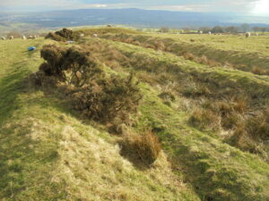
To the west of Copthurst, extending for at least 500m, is a field system with earth bank boundaries; these had a triangular x-section. The banks were probably continuous originally, but now have gaps to allow vehicular access and perhaps provide shelter for sheep. Where the ground has been undisturbed the banks were accompanied by a broad, shallow ditch. It was thought this area could have been a vaccary area.
Near Higham. Spring 21.
Attribution: Ian Rowley
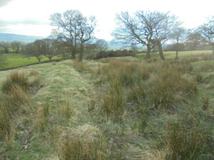
These fields are situated just south of Stump Hall Rd and we investigated a feature shown on the 1840s OS map extending from there to just north of Holly Hill. The feature looks like a road on the map, but was found to be two parallel earth banks. It is difficult to summarise the situation, but descending the hill the earth banks became further apart and additional banks and ditches appeared in places.
Returning to the top of the feature, there was a section of bank at right angles to the main structure. It is possible that this could be a dam to hold water for hushing in the gravel pits shown on the 1890s OS map. This interpretation was not universally accepted! The curved ditch, visible in Google Earth, could have collected the gravel while sorting it from coarse at the top to fine at the bottom. The water supply was now piped to the water trough some metres below the dam.
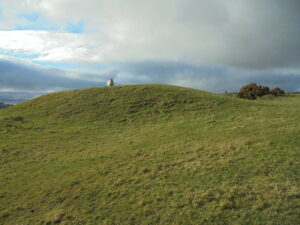
Near Higham, Spring 21.
Looking N towards possible ‘dam’.
Attribution: Ian Rowley
An enjoyable walk in the sunshine and we hope to do further investigation in the area.
Banner Image: Near Higham. Spring 21. Attribution: Ian Rowley