This field walk was to complete the investigation of the western postulated boundary and further examine the enclosures to the north of the site. We had an enjoyable time wandering around and conjecturing what the various ditches, boundaries and banks had to tell us, the conclusions are as follows. We also viewed the interesting vernacular architecture of local homes from the 17th century, Copthurst among them.
The western boundary was not proved and ceased at the point shown on the map.
The banks and ditches to the north of the boundary, together with their disposition, were hard to understand and no proposal is put forward for the purpose of these. However, it is known that gravel extraction took place. It is proposed that this boundary formed the northern edge of the postulated Brerecar, where there is a length of a strong bank with a ditch. This, together with the banks and ditches to the south are compatible to those of the late medieval period and could form the internal and external boundaries to the postulated cattle pool. It is clear that all the banks were not constructed at the same time and for a different purpose.
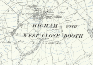
Map of Higham Area. Courtesy of D Taylor
The original proposal for the enclosure to be the cattle pool would appear to be too large in area and the proposed revised boundaries offer a much more practical solution.
Further research should confirm the boundaries to the proposed enclosure and establish the internal boundaries. Further documentary research should also be undertaken.
Banner Image: Copthurst Farm. Attribution: Bill Boaden